Showing posts with label hiking. Show all posts

Wednesday, March 17, 2010

Joshua Tree - Boy Scout Trail


Joshua Tree - Boy Scout Trail
~8 mi. one way

Driving:  Drop one car off at pick up point.  The pick up trailhead is about .5 mi. uphill from Indian Cove Ranger station, located south off of Hwy 62 on Indian Cove Rd. just west Twentynine Palms. 
Drive west on Hwy 62 to Park Ave. in Joshua Tree town. Turn Left. Enter JTNP and drive to Boy Scout Trailhead (on left, about 10mi. from turn onto Park Ave.).  The drive from the pick up point to the starting trailhead takes approximately a 1/2 hour.  

Hike Overview: This one-way hike begins as a sandy, flat-ish trail for the first half of the hike or so out through the J-Trees and Wonderland of Rocks. There are some scenic rock outcroppings before the descent into the wash, which could be good lunch stops and/or water breaks. Good views out towards the west & the San Bernadino Mtns.
The trail descends moderately and ultimately 1,345’ total into a wash and changes character dramatically. Arrowhead symbols on posts mark the way once you start descending. Watch carefully for the trail -- in some places navigating can be tricky. The trail is rocky in spots and at one point, descends & switchbacks fairly steeply. If you use hiking poles, take them, even though it initially looks like you won’t need them. Trail goes into the sandy wash bottom on & off. It eventually descends down to the bottom of the canyon, out the last of the wash, and exits onto the flats for the last mile and a half or so. Look for desert bighorn sheep in the canyon.

There is a side trip available which branches off a little more than a mile out from the trailhead (Willow Hole, 2.3mi one way). The scenery is about the same, but if you want more miles, it is an easy way add them.

Hike Highlights:
• Scenic Joshua Trees
• Wonderland of Rocks formations & views of San Bernadino Mtns to the west
• Transition of terrain from start to finish
• Possible desert bighorn sighting – I saw at least three when I was running the trail!


Monday, March 15, 2010

Joshua Tree - 49 Palms Hike

We've been busy the past month!  We just returned from hiking in Big Bend, TX, and before that, Joshua Tree, CA.  It's full-on spring here in Colorado (that means basically nice days alternated with blizzards).  Where did the winter go?

Anyway, here's one installment of hike descriptions/photos to come...

• The park is named for the Joshua Tree, which is actually a type of yucca. Joshua Trees live primarily in the Mojave Desert, though a few can be found in the Sonoran Desert, Great Basin Desert, and San Bernadino Mtns.

• Two large desert ecosystems, the Colorado/Sonoran & the Mojave, come together at Joshua Tree National Park.

• Below 3,000’, the Colorado Desert (Sonoran) occupies the park’s eastern half. It is dominated by abundant creosote bushes but accented by spidery ocotillo and jumping cholla cactus.

• Higher, more moist, & slightly cooler, the Mojave Desert hosts its signature plant – the Joshua tree. Extensive stands characterize the park’s western half. Elevations are generally between 2,000 and 5,000 feet. Precipitation averages 3-5” per year. 

• Another ecosystem is the Pinyon/Juniper zone, found at high elevations in the Little San Bernadino Mountains. Panorama Loop/Warren Overlook & Peak hike visits this area.

• Five fan palm oases in the park.


Joshua Tree - 49 Palms Hike  3 miles R/T

To get to the trailhead, turn south off CA 62 onto Canyon Road (look for an animal hospital on corner) & drive to the parking lot at the end of the road.
Hike Overview: The hike is a good introduction to the area. Moderately strenuous. It has approx. 360 feet of vertical gain both directions.
Hike Highlights:

• Views of the town of Twenty Nine Palms and out towards the marine base 

• Small natural fan palm oasis at the turnaround point.

Hiking up & over the hill towards oasis in the distance

49 Palms Oasis
Approaching the oasis

Monday, January 11, 2010

Review of 2009


2009 began with me in massage therapy school in Santa Fe, NM.  Art was more or less restricted to anatomy flashcards and the occasional illustration (see below).


During school break in January, we took a short road trip to the Las Vegas (NV) area.  Stopped at Hoover Dam along the way.  One of the highlights of the trip was visiting "Bodies: The Exhibition" at the Luxor as well as seeing my third Cirque du Soliel show, "Mystere".  Love the art at the dam (above), and the creativity and colorfulness of the Cirque shows (check out "KA" if you get to Vegas, especially if you are a climber).  "Bodies" was truly amazing -- if you have interest in actual dissected human anatomy, this exhibit was very educational and done in respectful taste! 


Two illustrations finished while in school -- Ice Lake Basin (L) and Kalalau Trail (R).


I ran past several sculptures along Canyon Road* in Santa Fe while training (Feb, Mar) during second semester at NMAHA for a half marathon (the Flying Pig, in Cincinnati -- May).  You can run right up Canyon to Upper Canyon Road and access several of the Dale Ball Trails.  My favorite long run went up this way, up & over to Hyde Park Road, then back to Canyon, Alameda, and ultimately down Agua Fria. 

*Canyon Road is an area of Santa Fe with many art galleries.  Check it out if you get down there, as well as the Dale Ball Trails.  You could even book a massage at the New Mexico Academy of Healing Arts graduate or student clinic! 


A winter shot of one of the Dale Ball trails above Santa Fe.  You can do a couple miles or many on nice, singletrack trails!


After school finished in March, we road-tripped down to Carlsbad Caverns NP & Guadalupe NP.  This shot shows the natural entrance to the cave... it's amazing!  You descend, descend, and descend some more to get down to the main area.  They do not let people hike back out, though.  You have to take the elevator!  Go figure!


A nice sunset shot of ocatillo silhouettes.  I love New Mexico!


Yucca at White Sands, NM, on the same road trip.


Ahhh, Moab! While camping up on Sand Flats road isn't free anymore (gosh, that's been a long time ago), it's still beautiful with the La Sal Range in the background.  Best of both worlds, mountain & desert!  We rode a few new mtn bike rides... can you believe I had never been on the ride to Klondike Bluffs?!  Somehow in the past, I would always end up in Moab on my own.  Caution kept me to the most popular trails (i.e., Slickrock, Porcupine Rim).  Steve discovered running on  the Slickrock Trail and prefers that to biking it.

May took us out east, to lead the Kentucky Bluegrass bike tour.  Along the way, we stopped in Cincinnati to visit Steve's relatives and run 'The Flying Pig'.  Steve qualified for Boston in the marathon.  My trail running body is not so fond of pavement.  However, I managed to finish my first half marathon on pavement.  The hardest part, though, is not the running.  It's waiting in line to use the porta john (and will cost you valuable time, I might add)!  LOL.


June took us out to Oregon -- did I mention we drive a LOT?  Working seasonally for a tour company that does tours all over the west takes us, well, all over the place.  It can be a challenge to get from Denver to the west coast in a few days and throw in a couple of workouts.  Who says tour guides have an easy way to stay in shape?!  I beg to differ.  :)

This shot (above) is from the Dog Mountain hike.  It's on the Washington state side of the Columbia River Gorge.  The hike itself is only about 7 or 8 miles R/T, though steep, and you get to see a nice view of the area, provided the weather cooperates.  You can also get a glimpse of Mount Hood...


This is Mt. Hood (above) albeit from Timberline Lodge!  There's a really fun hike called 'Tom, Dick, & Harry Mountain' just south of Mt. Hood.  I've never been able to get a good photo from the top (maybe this year?) but trust me, it's a moderate, user-friendly peak.  Check it out if you are in the area.  If you do it in June, you might see some of the rhododendrons blooming.  Pretty cool!


Lupine & Mt. St. Helens taken from the Ape Canyon trail, I think.  We were on some days off in late June and had to head from the Portland, OR, area down to Yosemite.  We took our time driving the coast to get down there as well as visiting the Tillamook Cheese Factory!  Check it out if you are wandering in that area -- they have fantastic ice cream!


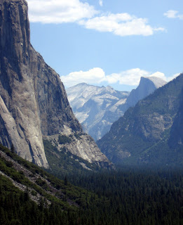
Classic Yosemite Valley with El Capitan (left foreground), Half Dome (back right), and Clouds Rest (back center).  I would soooo love to spend more time exploring Yosemite's backcountry.  Guess I'll put it on the list...!


I just like this pic of one of our guests, Katie, taking a break along the Panorama Trail that goes from Glacier Point to Yosemite Valley.  That's Half Dome in the background.  This is a must-do hike if you can get out there.  Classic.


August found us in Glacier Park, MT, leading a bicycle tour.  It's easy for me to lead a tour in Glacier as it is one of the most beautiful places in the USA where I've been fortunate enough to spend a good bit of time.  The mountains there are distinctive: sort of a slate gray, very angular, with turquoise lakes nesting in valleys.  Flora & fauna abound... moose, sheep, mountain goats, wildflowers of all sorts, huckleberries!  Truly an amazing and magical place.  When people ask me where's my favorite place, I'm often tempted to say Glacier.  Just tempted, though.  What about Yosemite, Grand Canyon, Grand Teton/Yellowstone, Rocky Mountain, Bryce/Zion, Hawaii, etc.?  We are so fortunate to have these places all in our country!  Unbelievable. 


Isn't this an incredible trail?  This is coming down off of Alta Peak, in Sequoia NP in September.  Our whole gang made it to the summit.  My photo from the top didn't turn out that well but I think this one shows more of what the hiking was all about near treeline.  We certainly had a "Peak Climbing Day".  The weather held and better yet, everyone made it down in time for dinner!

I didn't list all of our wonderful trips from '09 (such as the Northern New Mexico Alpiner, one of my all time favorites -- didn't I say it was hard to choose?).  It was a tough season what with the economy and all, but I must say I was grateful.  Grateful for all the wonderful people I met along the way.  Grateful that I finished school.  Grateful that I enjoyed some tours/work.  Grateful that we were able to visit some pretty cool places (did I mention Olympic NP?).  I can only hope for and work towards making 2010 just as awesome! 

P.S. Just added that 'Follower' gadget today!

Sunday, April 6, 2008

South Kaibab Trail


From left: Cedar Ridge, S. Kaibab Trail; Russell admiring Inner Canyon; View of Colorado River & Silver Bridge.


Laurie admiring Inner Canyon; S. Kaibab Trail snaking its way to the river. Below: A dramatic day on the S. Rim; Mule train ascending S. Kaibab; Edgy trail near Skeleton Point.


Right: Black Suspension bridge over the Colorado River; looking down to the river from S. Kaibab Trail;


Saturday, April 5, 2008

Waterfall Day!


From top: Havasu Falls; Laurie at Havasu Falls; John & Kathleen at Havasu; Group admiring the falls; At the base of Mooney Falls; John exits tunnel on Mooney ascent; Russell, Maria, Steve halfway up the ascent from Mooney; Russell begins ascent; Waterfall yoga; Steve practicing "tree pose".


Monday, January 7, 2008

Inspiration: A Favorite Hike

Upper Grinnell Lake in Glacier National Park is one of my all-time favorite hikes. This out & back trail, an approximately 12-mile return from Many Glacier Hotel to the upper lake and back, is popular -- for good reason!

Begin at either Many Glacier Hotel or the Grinnell Glacier Trailhead (located at the Many Glacier Picnic area). While hiking along Swiftcurrent Lake, pay attention! Both black and grizzly bears frequent the Many Glacier area. Trail postings can be checked at the hotel bell or transportation desks. There is a great write up of the hike
here.

If you start early, you might be lucky enough to catch the reflection of Mt. Gould in Lake Josephine (photo). Reminiscent of the Maroon Bells in Colorado, Mt. Gould is one of the most photographed and recognized peaks in Montana. Its angled summit rises atop the Continental Divide.


The trail climbs moderately from the junction on the north side of Josephine, hugging the mountainside beneath Mt. Grinnell. Impressionistic painting comes to mind during mid-summer, when the slopes along the trail boast some of the most colorful and diverse wildflowers I've ever seen. (See photo for bear grass "Q-tips" and pink subalpine spirea.) Views of the turquoise, glacier-fed Lower Grinnell Lake are attained as you ascend toward the hanging valley above.

As you attain the moraine at the top, scan the cliffs above for mountain goats and sheep. Cresting the moraine, you are greeted with the milky, iceberg-filled Upper Grinnell Lake. Notice the waterfalls draining from the shrinking Salamander Glacier on the rock wall in front of you (see photo). The arete, or knifedge ridge, above the Salamander traces along the Continental Divide. Relax and enjoy the view, you deserve it!