Friday, March 26, 2010

New Drawing

Here is a 5"x5" drawing done in ink & Lyra colored pencils (the colors are richer than in the photo).  Just playing with simple designs.

I can tell I've been living in a "river" town all winter since I'm starting to draw kayaks!  Hope you have a great weekend. 

Wednesday, March 24, 2010

Weekend Ski Tour

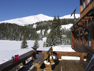
View of Homestake from 10th Mtn Hut

View south towards Mt. Elbert from 10th Mtn Hut

Headed out for the ridge above the hut

Here are a few pictures from last weekend's 10th Mtn Hut ski tour.  It had snowed Friday night so conditions were great (and cold) on Saturday morning.  We parked at the Crane Park TH, just south of Tennessee Pass near Leadville.  It was one of our group member's first time touring so we took our time, making the 3.5 mile trek in to the hut in about four hours.

The hut location is beautiful (see pics above) with views of Homestake Peak (elev. 13215 feet / 4027 m) to the west and Mt. Elbert (elev. 14,440 feet / 4401 m) to the south.   

Spring visited us again on Sunday.  Temps warmed up above freezing.  After our trek up to the ridge just NE of the hut, the snow conditions deteriorated and got quite sticky!  We got a good workout, though, LOL. 

Skiing out Monday morning was a challenge as we made our way down 2.5 miles of frozen snowmobile tracks... yikes.  Most of us ended up donning our skins to help slow us down.  The last two miles of trail were designated as "ski only", making the final leg of the trip *much* easier! 

Monday, March 22, 2010

New Painting

2' x 2'
Night Ski

This is the acrylic rendition of "Night Ski" that I've been working on recently.  I don't know if you can see how the background goes from darker to lighter blue (top to bottom), but I really like how this turned out.  Each painting seems to get a little bit easier... I think that's how it's supposed to work!

Hope everyone had a great weekend.  Spring is definitely here in Colorado -- one day it snows a foot, the next day is sunny and 60F! 

Wednesday, March 17, 2010

Joshua Tree - Boy Scout Trail


Joshua Tree - Boy Scout Trail
~8 mi. one way

Driving:  Drop one car off at pick up point.  The pick up trailhead is about .5 mi. uphill from Indian Cove Ranger station, located south off of Hwy 62 on Indian Cove Rd. just west Twentynine Palms. 
Drive west on Hwy 62 to Park Ave. in Joshua Tree town. Turn Left. Enter JTNP and drive to Boy Scout Trailhead (on left, about 10mi. from turn onto Park Ave.).  The drive from the pick up point to the starting trailhead takes approximately a 1/2 hour.  

Hike Overview: This one-way hike begins as a sandy, flat-ish trail for the first half of the hike or so out through the J-Trees and Wonderland of Rocks. There are some scenic rock outcroppings before the descent into the wash, which could be good lunch stops and/or water breaks. Good views out towards the west & the San Bernadino Mtns.
The trail descends moderately and ultimately 1,345’ total into a wash and changes character dramatically. Arrowhead symbols on posts mark the way once you start descending. Watch carefully for the trail -- in some places navigating can be tricky. The trail is rocky in spots and at one point, descends & switchbacks fairly steeply. If you use hiking poles, take them, even though it initially looks like you won’t need them. Trail goes into the sandy wash bottom on & off. It eventually descends down to the bottom of the canyon, out the last of the wash, and exits onto the flats for the last mile and a half or so. Look for desert bighorn sheep in the canyon.

There is a side trip available which branches off a little more than a mile out from the trailhead (Willow Hole, 2.3mi one way). The scenery is about the same, but if you want more miles, it is an easy way add them.

Hike Highlights:
• Scenic Joshua Trees
• Wonderland of Rocks formations & views of San Bernadino Mtns to the west
• Transition of terrain from start to finish
• Possible desert bighorn sighting – I saw at least three when I was running the trail!


Monday, March 15, 2010

Joshua Tree - 49 Palms Hike

We've been busy the past month!  We just returned from hiking in Big Bend, TX, and before that, Joshua Tree, CA.  It's full-on spring here in Colorado (that means basically nice days alternated with blizzards).  Where did the winter go?

Anyway, here's one installment of hike descriptions/photos to come...

• The park is named for the Joshua Tree, which is actually a type of yucca. Joshua Trees live primarily in the Mojave Desert, though a few can be found in the Sonoran Desert, Great Basin Desert, and San Bernadino Mtns.

• Two large desert ecosystems, the Colorado/Sonoran & the Mojave, come together at Joshua Tree National Park.

• Below 3,000’, the Colorado Desert (Sonoran) occupies the park’s eastern half. It is dominated by abundant creosote bushes but accented by spidery ocotillo and jumping cholla cactus.

• Higher, more moist, & slightly cooler, the Mojave Desert hosts its signature plant – the Joshua tree. Extensive stands characterize the park’s western half. Elevations are generally between 2,000 and 5,000 feet. Precipitation averages 3-5” per year. 

• Another ecosystem is the Pinyon/Juniper zone, found at high elevations in the Little San Bernadino Mountains. Panorama Loop/Warren Overlook & Peak hike visits this area.

• Five fan palm oases in the park.


Joshua Tree - 49 Palms Hike  3 miles R/T

To get to the trailhead, turn south off CA 62 onto Canyon Road (look for an animal hospital on corner) & drive to the parking lot at the end of the road.
Hike Overview: The hike is a good introduction to the area. Moderately strenuous. It has approx. 360 feet of vertical gain both directions.
Hike Highlights:

• Views of the town of Twenty Nine Palms and out towards the marine base 

• Small natural fan palm oasis at the turnaround point.

Hiking up & over the hill towards oasis in the distance

49 Palms Oasis
Approaching the oasis